The Ovens River Basin is located in north-east Victoria and covers an area of 7,985 km 2. The area extends from the Murray River in the north, to the Great Dividing Range in the south and is bordered by the Broken River Basin in the west and the Kiewa River Basin in the east. The topography of the Basin is diverse ranging from riverine plains near the Murray River and broad alluvial valleys around Myrtleford, to rugged alpine peaks and plateaux around the Great Dividing Range. Mt Buffalo, a large granite massif in the south of the basin, is an important landscape feature.
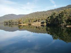
 Lake William Hovell
The Ovens River flows in a north-westerly direction from the high country near Mt Feathertop and Mt Hotham. The Ovens River and its upstream tributaries - the Buckland, Catherine, Dandongadale, Buffalo and Rose rivers - have their headwaters in the Great Dividing Range, in the section extending between Mt Cobbler and Mt Hotham. The King River, situated west of the Ovens River, has its headwaters on the Great Divide east of Mt Buller. The Ovens and the King Rivers meet on the riverine plain at Wangaratta. The main storages in the basin are Lake Buffalo on the Buffalo River and Lake William Hovell on the King River.
In the central portion of the Basin, wide valleys have developed along the Ovens and King Rivers. Below Wangaratta, the Ovens River takes in the water of Reedy and Fifteen Mile Creek and meanders northward across the riverine flood plain to flow into Lake Mulwala on the Murray River in the north-west corner of the Basin.
Rainfall and surface hydrology
Generally, rainfall is greater in the high country of the south of the catchment than in the northern regions along the Murray. The high country generally contributes greater run-off due not only to greater precipitation, but also to the steep slopes and thin soils. The regions of maximum run-off are Mt Buffalo, the ridge between the Buffalo and Buckland Rivers, and the mountains between the Rose and King Rivers.
Rain is the main form of precipitation in the Ovens River Basin. At elevation 1,400m, a large proportion of the winter precipitation falls as snow. Much of the high ground is snow covered from June to October. This high land forms an obstacle to the moist west winds and tends to intensify rainfall.
Sixty-five percent of the average annual precipitation occurs during winter, while in summer, when the polar front has moved southward, the prevailing weather is warm and dry. This warm air can carry large quantities of water so, although summer rain is infrequent and erratic, the few falls that occur are often heavy. Corresponding to the rainfall pattern, stream flow is highest in winter and early spring with some of the latter flow attributable to snow-melt.
Below Lakes Buffalo and William Hovell, streamflow readings indicate that at both sites regulated flow is slightly less than pre-regulated flow.
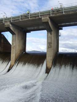
 Lake Buffalo
Groundwater
Within the Ovens River Basin there are two shallow aquifer systems. In the northern half of the Basin, ‘shoe string' sands are randomly distributed throughout the predominantly silty and clayey Shepparton formation of the riverine plain. In certain areas the groundwater tends to be saline. It is, however, widely used for stock and domestic purposes and for irrigation. Palaeozoic basement rocks composed of folded sediment, metamorphic rock and granite underlie the southern half of the Basin, and extend up the western boundary and also the Baranduda and Pilot Ranges. Aquifers in these rocks yield relatively fresh water from fractures and weathered profiles.
A deep sand aquifer known as the Cavil/Renmark Aquifer is restricted to the ancient valley of the Ovens River and lies approximately 80 to 100 meters below the present stream course. Groundwater quality in the Basin is generally good, especially that yielded from the basement aquifer. The Shepparton formation aquifer in the northern third of the basin contains groundwater of variable quality, as illustrated in the groundwater quality map.
Land use
For many years tobacco was the most economically significant crop in the basin and Ovens/King region generally produced three-quarters of the tobacco grown in Victoria. Other important agricultural activities along the Ovens and King Valleys are livestock production, sheep for meat and wool, beef cattle and some dairying. In the central and south-eastern regions of the Basin, hardwood logging and forest grazing are important. Agriculture is confined mostly to the central region and in the north-east, between Beechworth and Chiltern. In the north-east, forest grazing, beef, wool and fat lamb production are also important.
Ovens water storages
Although the district lies in one of the most favoured rainfall areas of the state, the increased demand for irrigation over the past 15 years has almost completely committed the developed resource of most streams. On two such stream systems, the Buffalo River and the King River, storages have been built to safeguard supplies and to allow for additional irrigation.
Total average annual water use in the Basin is 29,580 ML. Approximately 55% of the water is used by private diverters for irrigation in the Basin. The vast majority of water for urban and industrial use is drawn from surface resources within the Basin. A small quantity of water is extracted from the groundwater resource for commercial use, and reclaimed water is used for parks and gardens. Water for rural use is all self-extracted from the groundwater resource; approximately half is withdrawn from divertible resources and half from minor sources.
Lake Buffalo is located on the Buffalo River, 24 km south of Myrtleford in north-eastern Victoria.
Lake William Hovell is located on the King River 18km south of Cheshunt in north-eastern Victoria.