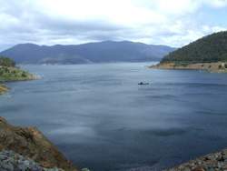
 Dartmouth Dam
The Upper Murray River Basin forms the catchment of Hume Reservoir and covers an area of 15,280 km 2 in New South Wales and Victoria. The Murray River forms the north and east sides of the Victorian part of the Basin. The southern boundary extends across the Dividing Range from Forest Hill to Mt Hotham, and the western boundary runs north between the Kiewa and Mitta Mitta Rivers to Lake Hume.
The Victorian portion of the Upper Murray River Basin covers an area of 10,150 km 2. It is subdivided into two components - the Mitta Mitta River catchment and Northern section of the basin which drains into the Victorian bank of the Murray River. Flows are regulated by Hume and Dartmouth Reservoirs, owned by G-MW and operated by Murray Darling Basin Authority under the Murray Darling Basin Agreement. Under the agreement, the regulated flow in the Murray River at Albury, which includes inflows from the Kiewa River, is shared equally by New South Wales and Victoria, subject to those States contributing equally to the annual flows guaranteed to South Australia of 1,850,000 ML in a normal year. The Upper Murray River Basin gains approximately 600,000 ML per year from inter-basin transfers via the Snowy Mountains Hydroelectric Scheme to the New South Wales section of the Basin; that gain is shared in the same way as natural flows.
Land and Stream Network
The Mitta Mitta River catchment covers an area of 10,062 km 2 and comprises the upper tributaries of the Mitta Mitta River including the Big, Bundara, and Cobungra Rivers and the Hollands and Livingstone Creeks, draining water from the High Plains through a dissected landscape. In the centre of the Basin the Dartmouth Dam is situated amongst moderately dissected hills. Morass and Larsen Creeks and the Gibbo and Dart Rivers flow into Dartmouth Dam. From here the Mitta Mitta River continues in a north-westerly direction and takes in the waters of Watchingorra, Snowy, Little Snowy, Little Scrubby and Tallangatta Creeks before entering Lake Hume near Tallangatta.
The northern section of the Basin is composed of a series of mature valleys with broad alluvial flats and raised terraces. The waters of Cudgewa and Koetong Creeks originate on the Koetong uplands, one of three distinctively raised areas in the region. The north-eastern section consists of the broad alluvial plains of Corryong, Cudgewa and Thowgla Creeks.
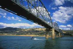
 Bethanga Bridge Lake Hume
Rainfall and Surface Hydrology
Climate varies widely over the Basin and topography is the single most important factor affecting this. Generally, rainfall increases according to elevation with the highest annual average rainfall in the catchment occurring at Mount Bogong in the south-west. In the northern section along the Murray River, the average annual rainfall decreases and in this area the rainfall variation is much higher than in the south. The main source of water is the rain, although, above 760 m, some precipitation falls as snow. The relationship between topography and climate and thus discharge is illustrated by the fact that land above 1,050 m comprises only 23 percent of the catchment area and yet produces only 43 percent of the total yield.
Along the Mitta Mitta River, mean annual flow can triple from Hinnomunjie in the south to Tallangatta in the north. Highest flows are in October and are attributable to the spring snow melt.
Groundwater
In the Upper Murray Basin the shallow aquifer system consists predominately of outcropping Palaeozoic-aged sedimentary rocks intruded in places by granites which are surrounded by associated metamorphic rocks. Older volcanic basalts cover a small area in the south of the Basin. Many of the streams have significant alluvial deposits along their tracts. The bulk of the resource is fresh; however a small region containing groundwater of marginal quality is located in the south-east corner of the Basin.
Land Use
All major valleys which lie in the north have been cleared for agriculture, although approximately 80 percent of the Upper Murray Basin still remains forested. The principal forms of land use are water conservation, forestry, grazing and agriculture. Dairying is the major industry. The grazing of sheep for wool and meat, and beef cattle fattening are also important. On the High Plains in the central and south-west, graziers run cattle on public and private land. There are severe erosion problems in the Omeo-Benambra area associated with the clearing of land.
Storages
Dartmouth Dam is located downstream of the confluence of the Mitta Mitta and Dart Rivers, approximately 24 km east of Mitta Mitta in North-Eastern Victoria.
Hume Dam is located immediately downstream of the Murray River and Mitta Mitta River confluence, 16 kilometres east of Albury-Wodonga. The dam is 305 km from the mountain source and 2,225 km from the Murray mouth at Goolwa.
Yarrawonga Weir is located on the Murray River near the towns of Yarrawonga in Victoria and Mulwala in NSW. The Weir is approximately 230 km downstream of Lake Hume and 1,992 km from the Murray mouth.
Torrumbarry Weir is located on the Murray River, 35 km north-west of Echuca. Goulburn-Murray Water operates Torrumbarry Weir on behalf of River Murray Water, the internal water business of the Murray-Darling Basin Commission.
Mildura Weir and Lock 11 are located on the Murray River at Mildura in north-western Victoria.
Kangaroo Lake is one of the largest and deepest permanent freshwater lakes supplied by the Torrumbarry Irrigation System. It lies on the western side of the Murray Valley Highway between Swan Hill and Kerang.
Kow Swamp is a large water storage with a circumference of 15 kilometres and a capacity of 51,730 megalitres. It is located 3km south of Leitchville and 6 kms from Gunbower and is in the Shire of Campaspe. Mount Hope overlooks Kow Swamp.
Lake Boga is the most northerly of the Kerang Lakes and lies approximately 16 km south east of Swan Hill and 40 km north of Kerang. Lake Boga is on the north eastern edge of Victoria’s Mallee Region.
Lake Charm is one of a group of shallow natural lakes situated between Kerang and Swan Hill.