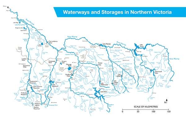
 Download a copy of our "Waterways and Storages in northern Victoria map by clicking the image above
Goulburn-Murray Water (GMW) is a statutory corporation established by Ministerial Order under the Water Act 1989 (the Act). It is governed by an independent Board of Directors, which operates under Part 6 of the Act and reports annually to the Minister for Water and the Treasurer.
Under the Act, we are empowered to provide, manage and operate:
- An irrigation district (Section 221)
- A water district (Section 163), and
- A waterway management district (Section 189).
As Australia’s largest rural water corporation, we manage, store, and deliver water through 10,000 km of delivery and drainage infrastructure, servicing over 25,000 customers across northern Victoria.
We manage 23 water storages with a combined capacity of about 11,400 GL and control more than 100,000 hectares of public land surrounding these storages. Our service region spans 68,000 square kilometres - from Corryong in the east to Nyah in the west - bordered by the Great Dividing Range to the south and the River Murray to the north. This area supports a diverse range of agricultural industries, including dairy, cropping, horticulture, beef and sheep.
We are also the appointed Northern Victorian Resource Manager, responsible for issuing seasonal determinations for all declared water systems in northern Victoria. As a key partner in the Victorian Water Register, we help manage over $7 billion in water entitlements and facilitate more than $300 million in annual water share and allocation trades.
We supply and support a broad range of stakeholders, including urban water authorities, environmental water holders, Catchment Management Authorities (CMAs) and the Murray-Darling Basin Authority (MDBA).
As Victoria’s largest inland boating authority, we manage recreational and boating activities across most of our storages. We maintain recreational infrastructure at 23 storages, including safe boating access at 16 of them. All GMW-managed dams offer varying levels of public access for recreational activities such as boating, fishing, and swimming.
Our complementary services portfolio includes:
- 724 houseboat licences
- Over 50 public boat ramps
- 673 occupational licences
- 245 agricultural licences
- 13 caravan park leases, and
- 62 community and club leases.
Additionally, 85 recreation reserves around GMW and MDBA storages are supported by funding from us, the MDBA, and local governments.
Customer segments
GMW's customer segments as at 30 June 2024
| Primary service segment* |
Example customers |
Number of customers* |
Annual water use |
| Irrigation |
Horticulture, dairy, mixed farming |
11,887 |
1,250GL |
| Domestic and stock |
Rural residential
Mixed farming
Intensive animal industries (eg. piggeries) |
9,851 |
28 GL |
| Environmental watering |
Commonwealth and State environmental water holders |
2 |
855 GL |
| Bulk water for urban and rural water supply |
Urban water corporations |
12 |
603 GL |
| Water investment |
Investment funds
Water share only customers
Agriculture corporations
|
3,017 |
31 GL |
| Flood protection |
Protection of land and property in flood protection districts |
54 |
0 GL |
| Recreation |
Houseboat operators
Recreation clubs |
1,323 |
0 GL |
| Commercial leasing and contract services |
Livestock graziers
Forestry corporations
Caravan parks
Murray-Darling Basin Authority
Local government and catchment management authorities
Commercial contracts
|
277 |
0 GL |
| Power generation |
Hydroelectric power utilities |
2 |
0 GL |
| Other |
Sundry customers |
88 |
0 GL |
| TOTAL |
|
25,770 |
2,628 GL |
* The customer segments have been identified using a single customer view methodology that groups customers based on their primary need. For example, if a customer accesses a gravity irrigation service and a domestic and stock service, they are classified as in the irrigation segment if their gravity irrigation charges exceed their domestic and stock charges.
Details of trades
Details of trades that GMW has been a party to are available from the Water Register Website. This is a requirement under section 12.38 of the Murray-Darling Basin Plan.